Feeds:
Posts
Comments

Archive for the ‘West Antarctic Ice Sheet’ Category

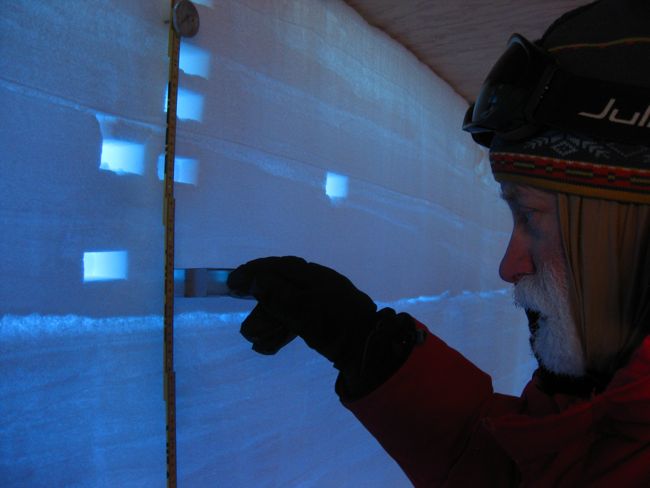
Last summer, several IGERT fellows had the serendipitous and rare opportunity to witness a warming climate’s effect on Greenland first-hand. Julia Bradley-Cook was stationed in Kangerlussuaq collecting data on carbon cycling in soil when the bridge over the Watson river collapsed from anomalously high flows of meltwater (see https://dartmouthigert.wordpress.com/2012/07/11/glacial-melt-threatens-town-water-supply and https://dartmouthigert.wordpress.com/2012/07/11/update-the-river-powers-on). Days later, the 3rd cohort of Dartmouth IGERT students flew up to Summit Camp, Greenland’s highest point, and observed features of the ice sheet-wide surface melt. Fellow Kaitlin Keegan, Thayer Professor Mary Albert, and their collaborators study the frequency of such melt events; their work at the North Greenland Eemian Ice Drilling (NEEM) sight has suggested that such an event last transpired in 1889 and, therefore, is unprecedented in the satellite record. (See https://dartmouthigert.wordpress.com/2012/07/21/new-summit-melt-layer).

A new Nature publication on Greenland climate authored by the NEEM community, which includes Albert and Keegan, prompted an entry on the scientific blog site RealClimate.org. RealClimate was started and is maintained by “working climate scientists” who “aim to provide a quick response to developing stories and provide the context sometimes missing in mainstream commentary.” Check out the discussion on Greenland’s 2012 summer conditions, how they compare to those 125,000 years ago, and what we can learn about past temperatures and sea level rise from an ice core! I was particularly excited about the conclusion of the entry since author Dr. Steig mentioned the significance of a new ice core from West Antarctica. I just returned from a field season on Roosevelt Island assisting with the drilling of this core, which will help scientists understand the sensitivity of the Ross Ice Shelf and, thus, of the West Antarctic ice sheet to changes in climate. http://www.realclimate.org/index.php/archives/2013/01/the-greenland-melt/

Read Full Post »

With the engineers and some drillers busying themselves with the replicate corer (“big drill”) and us corehandlers having finished with my array of shallow cores (“baby drill”), the science folks here at WAIS Divide have had the rare opportunity to dive into our list of side science projects that one usually runs out of time for at field sites.

One such project involved giving a couple drillers some experience with their Eclipse Ice Drill (“little drill”). If you believe the hype given the little drill at morning meetings, the little drill is dominating the big drill in terms of production. We now have a 120m borehole through the firn near camp. It’s cased and GPS’ed for future science endeavors.

Image

Mike Jayred, Elizabeth Morton, and Logan Mitchell working the little drill


 Image

[Pic 2: The driver’s seat of the little drill … you keep an eagle eye on your amperage (lowest dial) and your left hand on the “wheel”]

Image

The fleet of trusty of Alpine snowmachines that ferried us between camp and the little drill

Another project could be thought as I-477’s “thank you” to WAIS Divide camp. This year’s camp group is pretty phenomenal, and we pondered how we could express our appreciation for such an awesome collection of people. How about a 3-sided, backlit snowpit? What a wonderful idea … and an idea where we could also do some science! So John Fegyveresi, Logan Mitchell, and I dug 4 two-meter deep snowpits to create this mini-monster. A backlit pit, or “light-pit method” (R.M. Koerner, 1971) allows an observer to map the stratigraphy in great detail. Or, if you’re like me, the hidden blue beauty of snow simply awes you.

Image

A shot from a wall in the backlit snowpit … notice the interesting bedding

Image

A close-up of a few crusts and layers of differently-sized grains (my left pinky finger is for scale

Like Koerner suggested, we used the opportunity to map the stratigraphies along the back wall (parallel to dominant wind direction) and side walls. We also took density measurements.

Image

Don Voigt taking density measurements in the backlit snowpit

And we also took some pictures … lots of pictures, to show the breadth by which one can appreciate and enjoy a backlit snowpit.And we also took some pictures … lots of pictures, to show the breadth by which one can appreciate and enjoy a backlit snowpit.

Image

Logan and Gifford pointing to a humongous depth hoar layer

Image

Gifford pacing the width of the snowpit

Image

Logan and Gifford feeling “Matrixy”

Image

Gifford stretching out

Finally, this being a Sunday … I just had to write about the Saturday night dance party that spontaneously occurred at WAIS Divide. What started out as a poorly-heated Polarhaven with a wool blanket covering the door’s window, a decade-old boombox, a PC with music and DJ software, and our cook-cum-DJ, magically transformed into a multi-hour dance-fest. As you might imagine, the “poorly-heated” became over-heated quite quickly, but the music boomed until there was no one left to boogie. Obviously, pictures from this festivity “do not exist” … but just imagine, in the best possible way, the synergy among a dance club, winter camping, and a midnight sun. For those out there who have danced in icy or polar climes … I can see your smiles!

Read Full Post »

It is hard to believe that in 5 days I will be on an LC-130 Hercules flying towards McMurdo Station. This season has been especially fun … a great combination of cool camp staff and fun science. This will be the last blog sent from camp. Our GOES satellite connection is coming down tomorrow. I’d like to thank Marcus for taking my short, text-based emails and turning them into blog material!

Some of you may wonder what its like to wander “the streets” of WAIS. Short of documenting all of the cargo lines and winter berms, I thought I’d capture a few angles from camp’s main street.

Welcome to WAIS sign standing in front of the galley RAC tent

Looking toward the generator module and the Arch, with power lines connecting camp to the “gen mod"

Most of main street: “camp” Jamesway, “KBA” Polarhaven, Medical RAC tent, Recreation RAC and wash module, and galley RAC tent

The outhouses closest to the galley, with part of the cargo lines in the background

One of the interesting moments of this week has to be the viewing of the bottom of borehole WDC06A. Parts for the borehole camera finally made it to camp, and the first mission for the drill sonde was to visually inspect the borehole. The “flakes” you see on the left of the screen are left-over chips from previous drill runs. Notice the right side of the screen (the “uphill side”) is devoid of chips. Watching the camera run was quite surreal.

Lead Driller Jay Johnson “driving” the camera down the borehole with Chuck Zander watching … bottom of borehole in sight

A close-up of the bottom of the borehole (photo from Logan Mitchell)

Finally, what IGERT blog would be complete without a unicorn sighting? Indeed, after weeks of waiting, a unicorn was spotted on the WAIS Divide ski-way marshalling an LC-130 during flight ops for January 25. It is rumored that the unicorn got a thumbs up from the pilots from “Skier 32”

Unicorn?! At WAIS! (photo from Logan Mitchell)

I hope you enjoyed this mini-adventure to the West Antarctic Ice Sheet!

Gifford Wong reporting from WAIS divide via Marcus Welker

Read Full Post »

Older Posts »